publications
2025
-
 Strain rates along the Alpine-Himalayan belt from a comprehensive GNSS velocity fieldNicolás Castro-Perdomo, Sigurjón Jónsson, Yann Klinger, and 3 more authorsJournal of Geophysical Research: Solid Earth, 2025
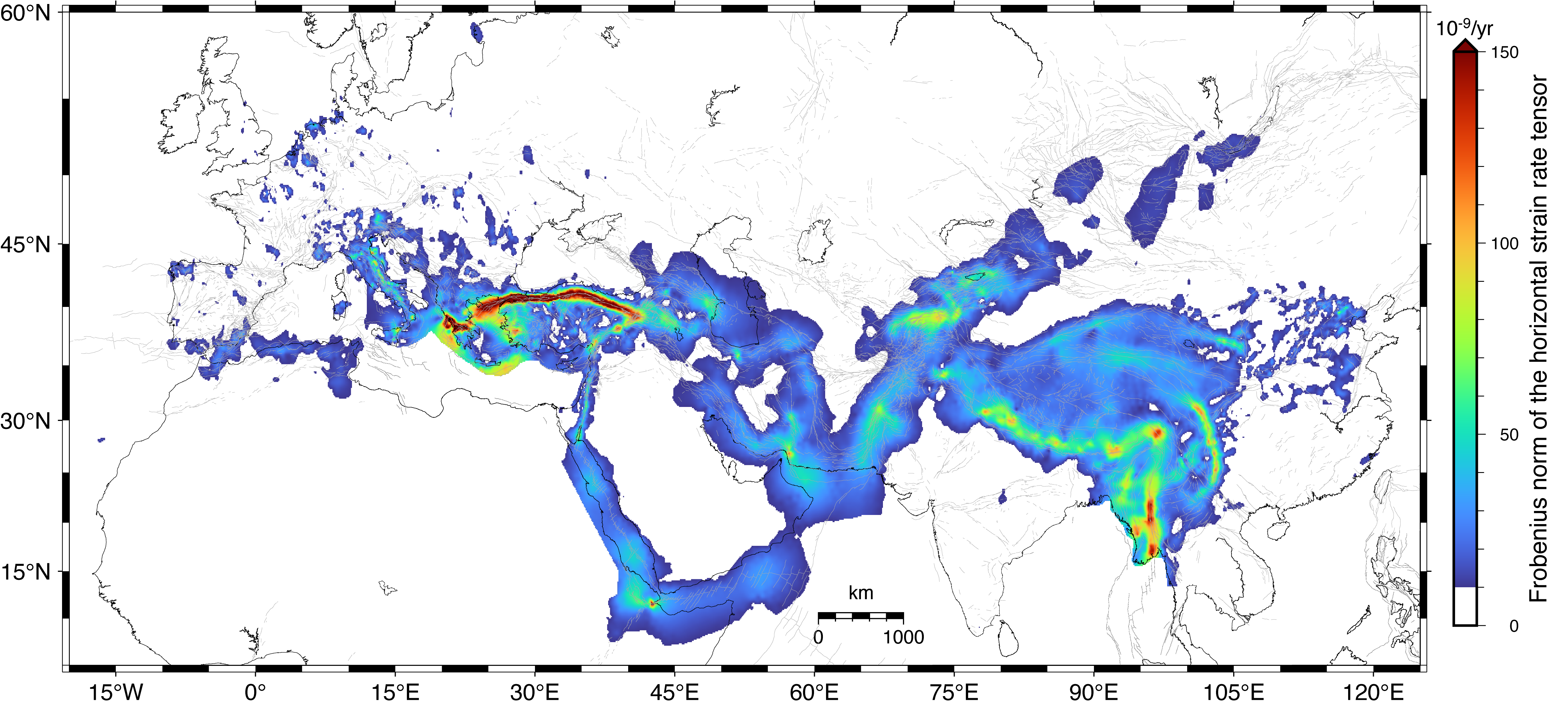
The Alpine-Himalayan belt is one of Earth’s most dynamic and complex regions, characterized by intense tectonic deformation and seismicity. Comprehensive analyses of continental-scale crustal deformation and seismic hazards along this extensive orogenic belt require the compilation of large geodetic data sets. In this study, we integrate 42 published Global Navigation Satellite System (GNSS) velocity fields, building an internally consistent data set for the entire belt, spanning from Iberia to Southeast Asia and comprising 11,177 horizontal and 3,940 vertical velocities. We use this unified GNSS velocity field to estimate surface strain rates and their posterior uncertainties in the eastern Mediterranean region and the India-Asia collision zone. Our results show large-scale agreement between the orientation and style of geodetic and seismic strain rate tensors across the belt. Additionally, our analyses substantiate previously documented azimuthal alignments between principal strain rate directions and seismic anisotropy orientations, often used as a proxy for finite strain in the convecting mantle. These correlations are particularly apparent in the Aegean, North Anatolia, Tibet, Tian Shan, Altai, Sayan, and Baikal regions, underscoring the need for future research on the relationship between mantle flow and lithospheric deformation.
@article{castroperdomo2025,
  title = {Strain rates along the Alpine-Himalayan belt from a comprehensive GNSS velocity field},
  author = {Castro-Perdomo, Nicol{\'a}s and J{\'o}nsson, Sigurj{\'o}n and Klinger, Yann and Masson, Frederic and Becker, Thorsten Wolfgang and Johnson, Kaj},
  journal = {Journal of Geophysical Research: Solid Earth},
  volume = {130},
  issue = {12},
  year = {2025},
  publisher = {Wiley Online Library},
  doi = {10.1029/2025JB031738},
  url = {https://doi.org/10.1029/2025JB031738},
  dimensions = {true},
}
2024
-
 Resolving the slip-rate inconsistency of the northern Dead Sea faultXing Li, Sigurjón Jónsson, Shaozhuo Liu, and 5 more authorsScience Advances, 2024
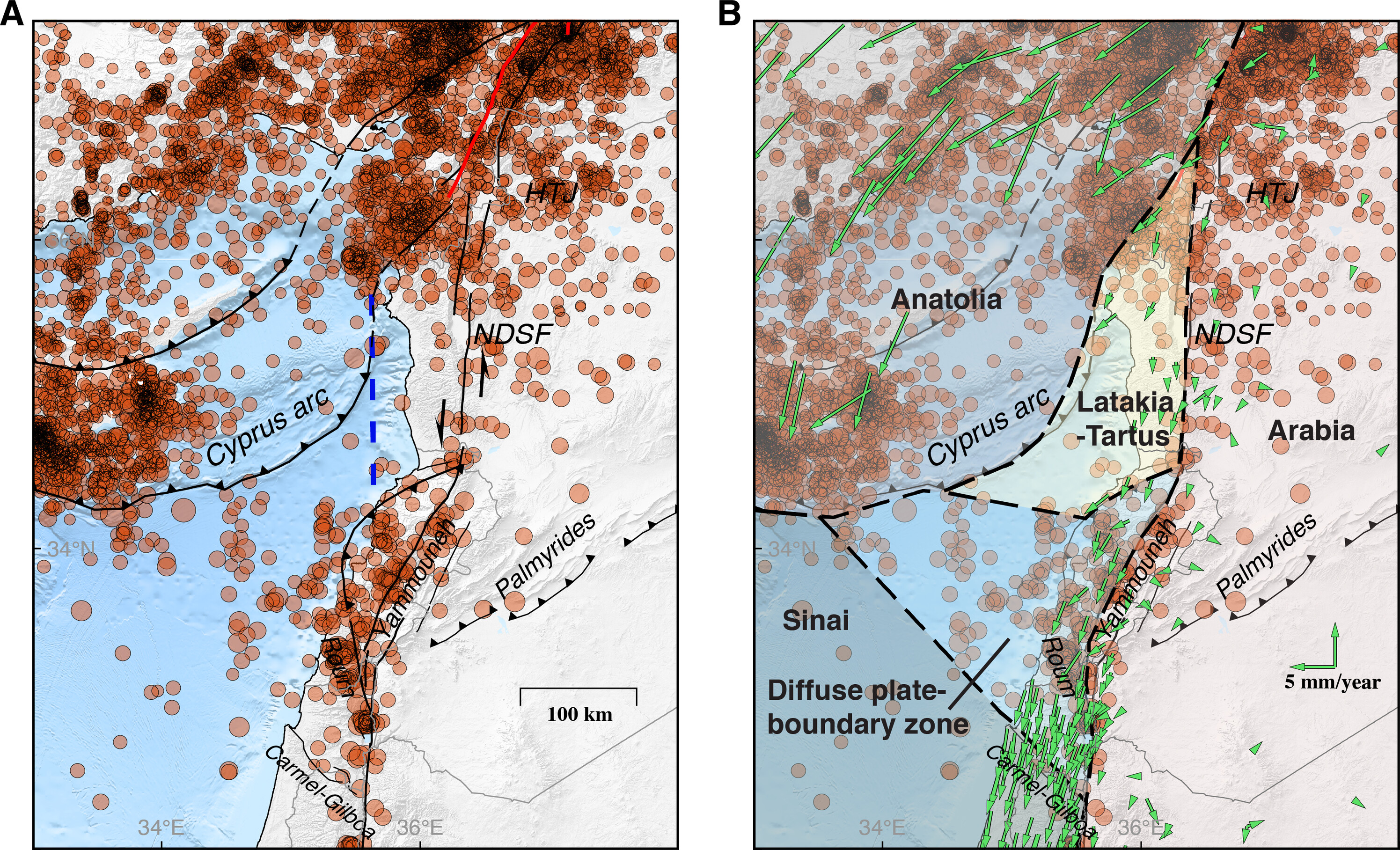
Reported fault slip rates, a key quantity for earthquake hazard and risk analyses, have been inconsistent for the northern Dead Sea fault (DSF). Studies of offset geological and archeological structures suggest a slip rate of 4 to 6 millimeters per year, consistent with the southern DSF, whereas geodetic slip-rate estimates are only 2 to 3 millimeters per year. To resolve this inconsistency and overcome limited access to the northern DSF in Syria, we here use burst-overlap interferometric time-series analysis of satellite radar images to provide an independent slip-rate estimate of 2.8 millimeters per year. We also show that the high geologic slip rate could, by chance, be inflated by earthquake clustering and suggest that the slip-rate decrease from the southern to northern DSF can be explained by splay faults and diffuse offshore deformation. These results suggest a microplate west of the northern DSF and a lower earthquake hazard for that part of the fault.
@article{lixing2024,
  title = {Resolving the slip-rate inconsistency of the northern Dead Sea fault},
  author = {Li, Xing and J{\'o}nsson, Sigurj{\'o}n and Liu, Shaozhuo and Ma, Zhangfeng and Castro-Perdomo, Nicol{\'a}s and Cesca, Simone and Masson, Fr{\'e}d{\'e}ric and Klinger, Yann},
  journal = {Science Advances},
  volume = {10},
  issue = {11},
  year = {2024},
  publisher = {American Association for the Advancement of Science},
  doi = {10.1126/sciadv.adj8408},
  url = {https://doi.org/10.1126/sciadv.adj8408},
  dimensions = {true},
}
2022
-
 Interseismic deformation in the Gulf of Aqaba from GPS measurementsNicolás Castro-Perdomo, Renier Viltres, Frédéric Masson, and 11 more authorsGeophysical Journal International, 2022
Although the Dead Sea Transform (DST) fault system has been extensively studied in the past, little has been known about the present-day kinematics of its southernmost portion that is offshore in the Gulf of Aqaba. Here, we present a new GPS velocity field based on three surveys conducted between 2015 and 2019 at 30 campaign sites, complemented by 11 permanent stations operating near the gulf coast. Interseismic models of strain accumulation indicate a slip rate of 4.9 mm/yr and a locking depth of 6.8 km in the gulf’s northern region. Our results further indicate an apparent reduction of the locking depth from the inland portion of the DST towards its southern junction with the Red Sea rift. Our modelling results reveal a small systematic left-lateral residual motion that we postulate is caused by, at least in part, late post-seismic transient motion from the 1995 MW 7.2 Nuweiba earthquake. Estimates of the moment accumulation rate on the main faults in the gulf, other than the one that ruptured in 1995, suggest that they might be near the end of their current interseismic period, implying elevated seismic hazard in the gulf area.
@article{castroperdomo2022,
  title = {Interseismic deformation in the Gulf of Aqaba from GPS measurements},
  author = {Castro-Perdomo, Nicolás and Viltres, Renier and Masson, Frédéric and Klinger, Yann and Liu, Shaozhuo and Dhahry, Maher and Ulrich, Patrice and Bernard, Jean-Daniel and Matrau, Rémi and Alothman, Abdulaziz and Zahran, Hani and Reilinger, Robert and Mai, P Martin and Jónsson, Sigurjón},
  journal = {Geophysical Journal International},
  volume = {228},
  issue = {1},
  year = {2022},
  publisher = {Royal Astronomical Society},
  doi = {10.1093/gji/ggab353},
  url = {https://doi.org/10.1093/gji/ggab353},
  dimensions = {true},
}